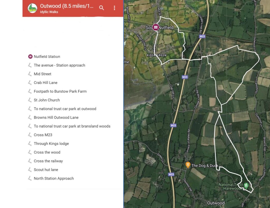
| Distance: 8 miles / 13.5 km |
| Start / Finish : Nutfield Station |
| Facilities: The Bell (Pub near the mill) |
| Must see: Outwood post mill |
| Hidden gem: Outwood common (the woodland) |

Intro
The walk passes fields, woodland, and one of the oldest windmills in the country. You may see sheep and donkeys. It’s popular with dog walkers too.
Walking route

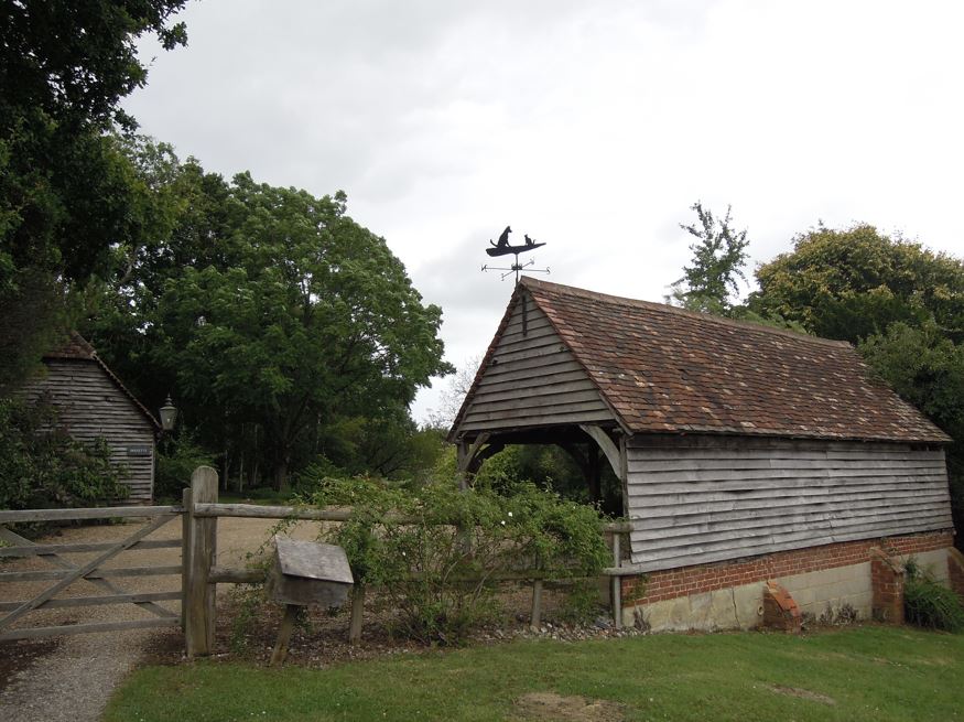
The barn with weather vane

The cricket ground

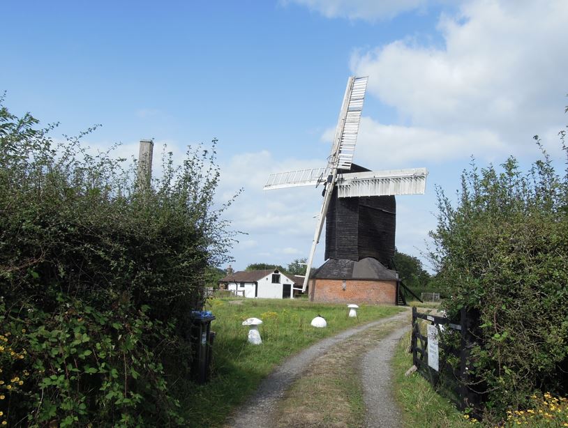
Used to be the oldest working post mill in the country
Out of the South side of the Nutfield train station (where the car park is). Turn left, walk along the Copse (Road). The Copse (Road) turns into South Station Approach. Then turn left onto the avenue. After about 200 meters where the Avenue ends, turn right onto Mid street. Walk all the way down the mid street, till you meet Kings Cross Lane. Turn left again, then 20 meters down the road, and turn right onto Crab Hill Lane.
Follow Crab Hill Lane for 150 meters. You will see a small triangle of green on your left. There’s a footpath hidden on the left-hand side of the road next to a black metal gate, which has an ESSE landscape sign. Turn left into the footpath. Follow the footpath till the M23 crossing.
Cross the M23 by the footbridge. Follow the footpath, which curves left, then onto Cooper’s Hill Road. You will see a red brick malting house opposite the road, with a small tower at the corner of the building. The sign says ‘HENHAW Farm’, a black sign underneath says ’The maltings’. Cross the road and take the path next to the malting house.
You will see a few more houses, then a tarmac road that leads to a metal barred gate, and a cross-way footpath sign. Turn right onto the lawn next to the barn with a dog and cat weather vane. The path descends slightly. Pass a small wooden gate that leads to a garden on your left. Take the stile ahead slightly to the right. You will see the ‘Do not feed the animals’ sign, with barbed wires and donkey hut in the small paddock on your right. Follow this path down. You may see two donkeys.
Then cross a footbridge into open field. Follow the footpath across the field. Turn left into the next field and follow the hedge.
At the end of the hedge, there’s a gap at the left corner of the field. Go through the gap in the hedge onto the field on your left. Follow the footpath and go through another fence into the next field. There’s a concrete footbridge on the opposite side the field. Cross a small stream. If the footpath is not visible, just head direct towards the footbridge.
Cross the bridge and follow the footpath on the right hand of the reeds. Keep the reeds on your left till end of the field. Then before you reach the next field, cross the gap in the hedge into the field on your left, then head diagonally towards the farm. You will soon cross the farm track onto a footpath on the right-hand side of the farm. There are blackberries and dog roses along the footpath next to the farm.
If the scaffold has been removed you will see an elegant regency building on your right inside the farm wall.
When you reach the farm track along the south side of the farm, turn right. At the corner of the road, there is a choice of three footpaths, two into the next field, one goes down the field.
Take the one that cuts through the next field. (ie. the middle of the three). It goes south west direction. Three fields later, you will enter some woodland. Follow the footpath straight through the wood and you will see St John the Baptist Church.
It’s an 18th century church with war memorials (next to the porch) and a separate graveyard.
After taking a look the church, return to the track along the side of the church. At the end of the track there are some houses. Turn right along the track, and you will find yourself back in the wood. There’re many paths in the wood. As long as you are following the same general direction you will either come out at the butcher’s shop, or the cricket club.
If you see the butcher’s shop, you need to continue the direction into the wood again and eventually you will come out at the cricket green.
Once you reached the cricket green, go round it and head towards the point furthest from the clubhouse. You will soon see the National Trust car park.
Walk through the car park and you will see the windmill opposite.
Cross the road, if you want to see the whole windmill. The windmill is private property and you cannot enter, but you can see the whole mill from the side from Gayhouse lane.
It was built in 1665; and before 2012, when a gale damaged one of the sails, was the oldest working windmill in the country, a title now hold by the mill at Cambourne, which was built before 1653, and is now working again, having been restored to its former glory.
After admiring the windmill, you may visit the Bell, the local pub. If you face the National Trust car park on Outwood Common, turn left on the road you just crossed and the Bell is 150 meters down the road.
Or go back to the Common, walk towards the houses on the right side. There’s a MOT garage, a bird house library on a post, painted bright blue with a lovely flower pattern. Follow the tarmac road back to the direct you come. Further down the track, you will see a farm on your right, then the National Trust estate office on your left. The track then turns into a footpath.
Keep going, follow the path through wood, then through a kissing-gate into an open field with a line of trees. MAke for the tree line and continue into the next field. It’s pretty much a straight line crossing several fields till you reach the Regency farm house again.
After you reach the north side of the farm track, turn right this time, instead of following the way you came. You will cross a field with a few trees scattered in the middle. Follow the trees, heading north east.
Cross the stream, into the next field, then you will see some woodland at end of it.
Go along the hedge till you reach the woodland and continue through it to emerge in the other National Trust car park with a pond at the end of it.
Go through the car park and turn left onto the road. 50 meters along the road, there’s a track divert from the road into a farm on your left. Take the track and follow it as it bends left passing by a farm house with apple trees on your right. Contine on the track till you reach Henhaw farm with the Malting house. (The track will bend right first where you will see unleashed Henhaw—a gated dog training ground, then bend left becoming a farm track with high hedges. It feels like you are walking directly into the farm, which you effectively are)
After the malting house, retrace the same path to cross the M23. 140 meters after crossing, you will see a footpath on your right, which turns into Kings Lodge Centre. Take that pat and go through the care home.
Cross Kings Cross Lane, turn left a few paces and there’s a metal gate with a kissing gate. Go through the kissing gate, take the footpath north. Go through the woodland. You will see an open patch. Turn left at end of the open patch. After a few paces into the wood again, turn right to cross the railway.
After crossing following the footpath towards north west direction. Then cross a field diagonally.
You will see South Nutfield Scout Hut at the left top corner of the field, turn into Scout Hut Lane.
Follow the lane further west. Turn left where the lane meets Mid Street. Follow Middle Street on to North Station Approach at the crossing.
Congratulations you are back at the station!
The village around the station is actually not Nutfield, but South Nutfield, which was established after the station was opened in 1842. The Nutfield village which is much older is 1.3 miles north of the station. The railway was built by the Southeast railway company, which ran trains between Redhill and Tonbridge, initially there was only a public siding called ‘Mid Street’.


Leave a Reply